
On March 27th 2010, Rachel and I boarded a plane to San Diego with three 45 pound checked bags, a travel guitar, and one small carry-on. We were on our way to spend 11 days at Joshua Tree and Death Valley National Parks. My mom (Rachel's Mother-in-heart) was visiting her cousin Jane in San Diego; Jane and her husband Brent's house was our first stop. We arrived plenty late in the evening, but Mom was still up. We had a quick dinner and Mom showed us around. After dinner we walked and talked in the front yard.
In the morning we got our first look at how beautiful Jane and Brent's house really is. It sits on a hillside with an unobscured view of the lush hills that surround San Diego. We had a delicious breakfast with Mom and Jane.

This would be the first
of many meals
that we would eat outdoors,
but probably the best...
Mmmmm strawberries.
After breakfast we got in our rental car and drove to Joshua Tree National Park. It wasn't a long drive and before we knew it we were entering our new temporary home, Black Rock Campground. Rachel had picked out our campsite online months earlier. As we creeped uphill through the campground looking for site number 30, we started feeling better and better about the potential quality of our campsite. The site we finally drove up onto was on the very top of the campground. There was nothing but a Joshua Tree filled wilderness uphill from us and the whole campground was below us.
 This would be your view
if you were staying
in one of the inferior
campsites down
hill from us.
How do we look
from down there?
Pretty good huh?
As is our routine, Rachel organized the car while I put the tent together. Her job was much harder then mine considering everything we needed to camp for almost two weeks was compacted into three luggage bags. The only organizational strategy we used to pack those bags was trying to ovoid the 50 pound weight limit imposed by the airline. They were a mess. We had sat on them to get them zipped up. She did a great job though.
After we moved in we explored the campground a little. We snooped around for a while to see who had the best campers and the biggest fires. Then we stopped in at our local ranger station. We talked to the ranger about good trails in the area and I bought a field guide for birds.
As it turned out, there was a trail that led right out of our campsite.

How
could
we
resist?
could
we
resist?
We headed off to walk around the Panorama Loop trail. If you've ever wondered why the park is called Joshua Tree it's because joshua trees are everywhere.
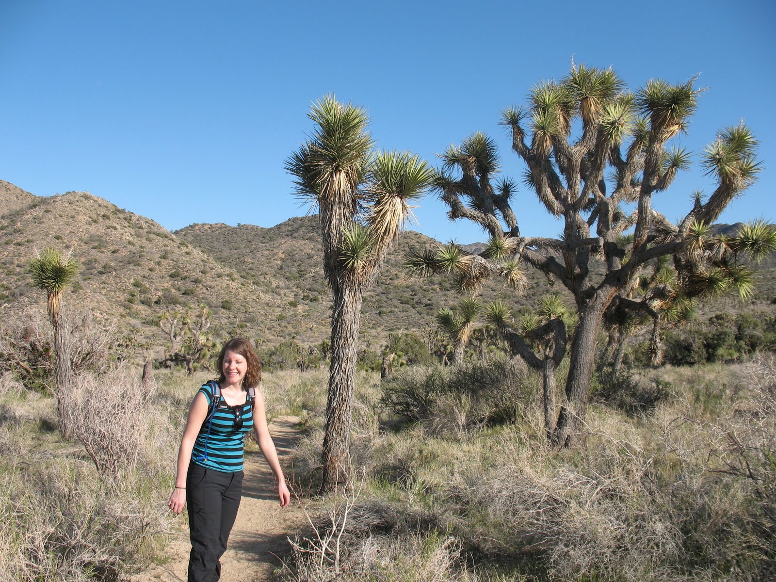
They
were
on our
left

and
our
right
our
right
In front
 and behind of us
 ( the little one isn't a Joshua tree ;)
They were even over our heads!

 It had only been 2 days since we dropped our dog Nesta off at Rachel's parent's (my parents-in-heart) house. We missed him already though. We started calling the little lizards Nesta. Nestas were everywhere, but I couldn't get a good picture of one because they ran away too fast. This little guy was a bit slower though. He's not as cute as Nesta but he's just as black, so he's got that going for him.
 Warren Peak is close to the Panorama Loop trail. The trail to the summit of the hill is only a mile long. While we were in San Diego, someone told us the sun would set at eight o'clock, so we figured we had plenty of time to take a little side trip. That's Warren peak in the little picture to the left. It's not too big of a hill, but we definitely broke our first sweat of the trip. The view was worth it.
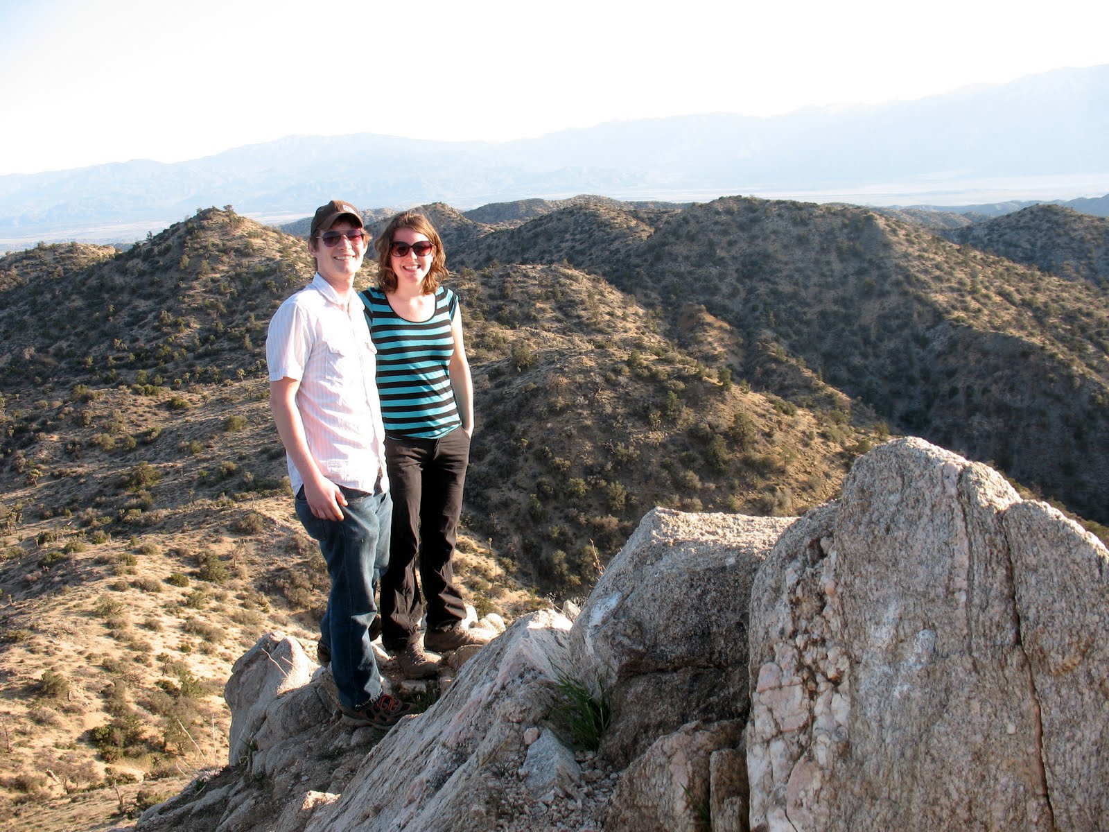
 There was a small jar at the peak
with a note pad in it.
Rachel Wrote down our names
and that life is good.
 This little guy was
hanging out on top
of the hill too.
We saw a lot of these
butterflies on our trip.

Look
a
triangulation
station!


We had a snack up there
and then walked back
to the loop trail.
We were full of energy
and terribly excited to be
on our first hike of the
trip. Rachel noticed how
the leaves of a small
yucca were daggers
and how a blade of grass
was just as curly as her hair!
and then walked back
to the loop trail.
We were full of energy
and terribly excited to be
on our first hike of the
trip. Rachel noticed how
the leaves of a small
yucca were daggers
and how a blade of grass
was just as curly as her hair!
Up ahead I saw a joshua tree that looked climbable.
I ran up to it and realized it was much harder to get into
then it had looked from farther away. I tried multiple ways up
and probably would have eventually made it, but the sun was hanging
suspiciously low in the sky and that made me think time wasn't an
endless commodity.

I ran up to it and realized it was much harder to get into
then it had looked from farther away. I tried multiple ways up
and probably would have eventually made it, but the sun was hanging
suspiciously low in the sky and that made me think time wasn't an
endless commodity.

This is me
standing in front
of the tree
that defeated me.

I packed up my pride and we hoofed it on down the trail. As we were walking we noticed some movement in the brush. It was a covey of Gambel's Quail. On our last National Park trip to Big Bend I mistook quail for roadrunner, but since then my birder big brother Paul has informed me of my mistake. They are elusive birds and this is the best picture of one I could get.

We made our way over the next ridge and noticed something disturbing in the sky. The moon was up in full. We started to worry that the sunset might be earlier then we had been told. We still had a few miles to walk an unfamiliar trail and doing that in the dark was a scary prospect. These thoughts kept us from fully enjoying the first sunset of our trip. It was still beautiful.

 After the sunset there was still enough light from the full moon to see the trail. We really got lucky because in our hast to go on our first hike we had forgotten flashlights. If the moon hadn't been full, or it had been the next night when the moon came out 45 minutes later we could have been in trouble. This was a good way to learn our lesson; scary, but harmless. When We finally got back to our campsite it was full on nighttime. It was great that the loop trail started at our campsite because when we were finally done hiking we were home.

I
made
up
some
grilled
cheeses
and
tomato
soup
and we had
a nice
dinner
in the dark.
 The next morning we awoke on top of the desert hill that was our campground. We had a few hikes planned so we ate a big breakfast. A Western Scrub Jay watched us eat from his perch atop a Joshua Tree. It was a gorgeous day, not a cloud in the sky and plenty warm. The first hike we had planned was the Lost Palms Oasis Trial. It is in the southeastern corner of the park and we were staying in the northwestern corner of the park. In order to see the rest of the park we had to drive though the towns of Joshua Tree and Twentynine Palms. At first we didn't like that we had to leave the park, but we started to enjoy being able to stop at stores on the way home. We could pick up firewood and any food we needed. We even bought a spatula because I had forgotten to pack one. It was also nice to be able to drive 70mph for part of the way. It was 70 miles to Lost Palms Oasis Trail and Joshua tree is not one of the bigger National Parks!
oh look, Nesta!

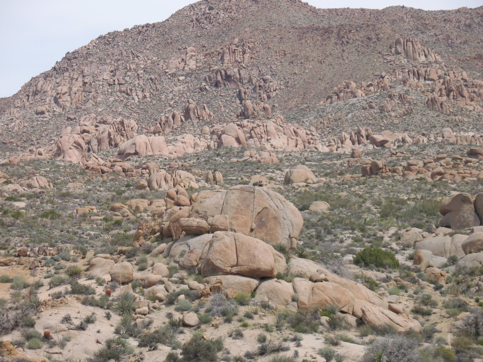
 The beginning of Lost Palms Oasis trail has a preview of the trails end. Giant Fan Palms (more specifically known as Wasiontonia filifera if you want to get all scientific) grow in a not-so hidden oasis. The trees are massive and their dried out leaves from previous years stay on some of the trees to form a sort of brown skirt that spans their entire length. As we started off down the trail we noticed that the plant life in this section of the park was much different then at our campsite. Black Rock Campground is on the base of the Little San Bernardino Mountains. These mountains mark a section of the border between the Mojave and Colorado Deserts. We were camped in the higher Mojave and now we were hiking in the lower Colorado Desert. The most obvious difference was there were no longer Joshua Trees, but a closer looked reveled many different types of plants.

We also noticed desert wildflowers!
You have to love springtime.


It was 4 miles to The Lost Palms Oasis. Our guide book stated that we would hope to see the oasis over every ridge line. At first we laughed at the books assumption, but soon I found myself scanning the horizon for palms. I was also looking for big horned sheep which were occasionally seen in the area. On a distant boulder I saw something!
We didn't bring a binocular on this trip so I took a zoomed in photo of the object. I was so excited to have spotted the first sheep of our trip! I snaped the picture, looked at my cameras LCD screen and.....

It was a stack of rocks. I don't know who would want to stack rocks way off the path and on top of a boulder. I blame yellow shirt guy. We first encountered yellow shirt guy at Big Bend National Park. We saw him walking towards us in the distance and when we got closer to him he disappeared into thin air. We were up in the mountains at the time, so the air was literally thin. DARN YOU YELLOW SHIRT GUY!!!!
We did have the opportunity to be too disappointed because this was the first hike of our trip and OH LOOK NESTA!
 And there's another Nesta!
These little guys were everywhere.
We had such a good time pointing them out
that before we knew it we were at the oasis.
 The Lost Palms Oasis a big grove of California Fan Palms in a deep canyon. We had an amazing view from the edge of the canyon so we decided to stop for lunch.
After lunch we walked down into the canyon and entered the oasis. The palm trees towered over us.


Soon there was no path
left to speak of and
there were hornets on
a lot of the underbrush;
we decided it was time
to turn around.
On the walk back up
a Costa's
Hummingbird
landed on
a branch above us.
He stayed for
a photo shoot.
It was a
beautiful bird.
left to speak of and
there were hornets on
a lot of the underbrush;
we decided it was time
to turn around.
On the walk back up
a Costa's
Hummingbird
landed on
a branch above us.
He stayed for
a photo shoot.
It was a
beautiful bird.

We continued up and out of the canyon and at the top we saw these two. They were too big for us to call them Nestas. In fact the big one is a Cuckwalla. I imagine the little one is a female Cuchwalla, but I'm no Herpetologist, so I'm not sure.


We walked back the trail we had come in on until we reached the Mastodon Peak trail. This was a small loop trail, only about a mile long. The Lost Palms Oasis trail we had just hiked was 8 miles if you add both ways. We hiked uphill for a while and soon saw a big rocky hill with people on it and a sign that said Mastodon Peak. We scramble up the back of the boulder pile and met the people who had just been up top on their way down. It was an older German couple and when Rachel first saw them she told me that if they could get up to the top then we surely could too. When they passed us the gentleman told us the same thing Rachel had just said! We could barley contain our laughter. It wasn't too hard to get up and soon we were on top of the world.


We watched the German couple
make their way down the trail
from their old vantage point.
We sat for a spell up there taking in our beautiful surroundings, but soon we wanted more adventure so we hiked on. We scrambled back down the rocks and trekked further down the path.

 Soon we reached an abandoned mine shaft. Rachel and I don't get too excited by the human history at National Parks, so we didn't stop for long. Mine shafts are extremely dangerous and unstable anyway. All the ones we saw on this trip were ether fenced off or had been blasted closed. Soon after the mine shaft Rachel and I spotted a desert tortoise. I took a few photos of the old guy. Desert tortoises are an endangered species because of their declining habitat and their tendency to get in the way of moving vehicles.
We continued down the Mastodon Peak trail and soon we saw the road we had driven in on. Mastodon Peak Trail is a loop trail that actually took us past where we had parked the car. Shortly after we noticed the road the trail forked. One path led to Cottonwood Campground and the other led back to the Lost Palms Oasis trail head. We took the later and it led us up a wash and then parallel to the road, but not quite close enough to the road to see it. There were interpretive signs posted along this portion of the trail and it was nice to read about the plant life in the area.
 Soon we were back to the car. We drove to the near by Cottonwood Campground to fill up our water. While we were there we saw a jackrabbit. I'm sure jackrabbits are nothing new to people who live in California, but to a couple of Illinoians it was an exciting moment. After we filled our water and rested up a bit we got in the car and drove to our next destination. Our trail guide book said there were dunes you could hike to on route to our campsite. We figured what better way to experience the desert then by getting our dune on. Actually, we had meant for the dunes to be our first hike of the day, but we drove right past the trail head without noticing it. On the way back we realized why we had missed it. There was no trail head because there was no trail. Upon further reading we realized our guide book suggested that we just start walking through the desert basin towards "the high point on the distant horizon." We were a little concerned about walking with no trail, but we figured the book we had is called "Best Easy Day Hikes: Joshua Tree" so how difficult could it be? I made careful mental notes on how the horizon looked, where we were going, where we would be returning too and used the compass I had remembered to bring on this trip to line the two points up. I felt confident we could walk without a path and return to the car, or at the very worst run into the road and have to find the car from there. Walking in a strait line would prove to be impossible because of the desert brush. We were forced to zigzag around clusters of thorny plant life. Eventually we mounted an incline that apparently was supposed to be the sand dunes. The Dunes themselves were nothing to email home about, but the view from atop them was. We could see for miles in every direction. The vastness of the Colorado desert was an impressive sight. I looked back from where we had come and could just barley make out a glint of light from where our rental car was.
Rachel and I had some beef jerky up there and then headed back. Once we got off the dune we lost site of the car. I used the point on the horizon I had picked out to walk towards and frequently check my compass. After a while we were at the car; there had been noting to worry about after all. We slumped into our seats, exhausted from the long day of hiking, and drove back to our campsite on the hill. It was nice to get home with some sunlight left. Just after sunset we heard drums and chanting coming from somewhere beyond the campground. It sounded like American Indian music, but the nearest reservation wasn't close enough to hear that clearly. It was eerie to have those drums hanging in the air so close to vast wilderness. I tried to get closer to the music, but as I walked thought the brush I realized I couldn't even pinpoint the direction the sound was coming from. The drums were echoing though a canyon and the dusk light was making it difficult to be sure of my footing. I decided a little mystery would be good for us and walked back to the campsite. We had beer with dinner and beer for dessert around the fire.
The next morning we were groggy.

It was
slow going
trying to getdressed and out
to another day of
hiking. But, just like
every other morning,
we put our pants
on one leg at
a time.
Eventually we got back in our rental car and headed off to go hiking. We planned a bunch of short hikes for this day and
 the first of these strolls was called Hidden Valley (Ranch) Nature Trail. It was a one mile loop and Rachel and I both agreed that it was a stupid hike for hikers and is really meant for rock climbers. There are rock walls surrounding the valley and people were climbing all over them. It was like a freakin' jungle gym. As slow moving as we were it was probably good that we started the day with an easy hike. In retrospect we probably would have disliked any hike at that moment. On this trail Rachel strongly professed her hatred of all dead trees. It wasn't long before we were back in the car and driving to Barker Dam Nature Trail. While parked in the Barker Dam lot we saw some
  beetles.
Barker Dam was another mile long hike, but this trail had more of a destination then the last one. As we were making our way to the dam we past a big group of kids with a Ranger. They were stopped at a boulder with some petroglyphs on it. The ranger was speaking, she said. "Now we've reached a point in the trip where we're going to do more walking and I'm going to do less talking, so you wont have to listen to me as much."
At this point an extremely audible whisper of "Yes" came from the crowd of children. Rae and I were far enough away where we could
 laugh out loud and wouldn't draw too much attention to the kid's adorable rudeness. We laughed all the way to Barker Dam.
Barker Dam was built around 1900 by ranchers so their cattle could get a drink. These days birds do most of the drinking at the pond. It was a strange site to see so much crystal clear water sitting still on desert rocks. We enjoyed the quiet beauty until that group of kids caught up with us. When they got close we got out of there.
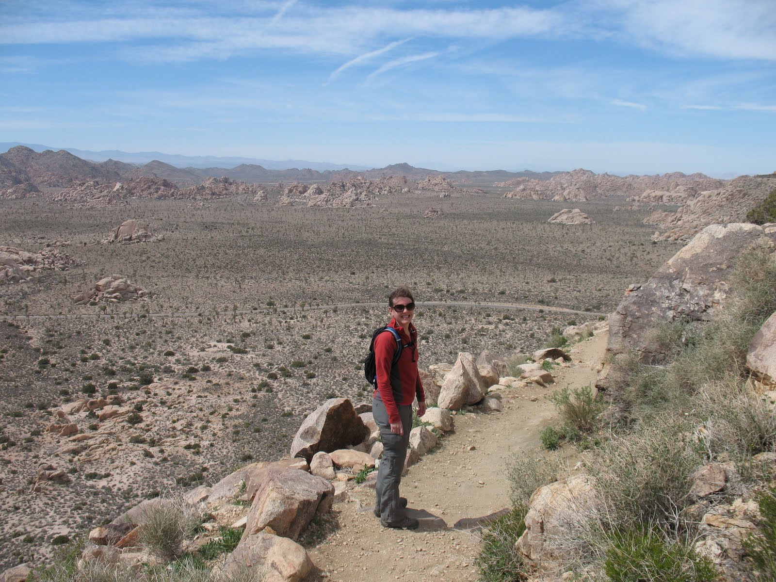
Our next stop was Ryan Mountain.

Ryan Mountain Trail is a 3 mile round trip'. The trail starts at the road and goes strait up Ryan Mountain. As far as peak hikes go, this trail is very rewarding for minimal effort. The trail has man made stairs on all of the steep inclines, but you're still hiking up a mountain, so it's no piece of cake. The top has a 360° view of the park from 5457 feet. We had lunch on the peak.

After lunch we headed back down the mountain.
Oh look, Nesta!


Our next stop was
Lost Horse Mine Trail.
Our guide book said we
should walk the 2 miles
to the Lost Horse Mine
and then turn around
and walk back. However,
the map we had shows a
6.2 mile loop trail that
goes beyond the mine
and back around to the
trail head. 6 miles seemed
like the perfect distance
 after all the short hikes
we had taken that day.
There had been a fire
the summer before so
the first stretch of
trail was pretty baron.
In this picture on the left
you can see that the fire was
stopped when it got to the trail.
Firefighters were able to save the
historic Lost horse mine as well
as half the mountain we were hiking on.

Once we got within sight of the mine, the path split. One route took a zigzagging course up the side of a mountain and ended at the mine itself. The other path went around another mountain. There was a young couple walking towards us on the path that went around the mountain. They told us they had planned to take the longer loop trail, but the path got hard to follow and they didn't want to get lost. We thanked them for the information and walked up the mine path to get a better look at Lost Horse Mine. We figured firefighters had work hard to save it so we'd better at least check it out. On the way to the mine we talked about whether or not we should still do the loop. We decided that we had a really good map and a compass and they didn't. We were going to do that loop dang it! After meandering around the mine for a bit pretending to be interested we found a quick way down to the main trail and made our way into the unknown around the mountain. Once we turned around a bend we got a bird's eye view of Pleasant Valley.

As we walked we kept our eyes open for big horn sheep. We didn't spot any sheep, but we saw flowering cacti.

We came across the remnants an audit (horizontal mine shaft) from lost horse mine.

We also walked past where the miners lived. Nothing was left but a chimney, the medal from a box spring and a lot of broken glass.

There were no other people for miles in every direction; the stillness was inspiring. We shared this wilderness with only the birds.

ohh, and the bees too. This hollow joshua tree had a busy hive in it.

A lone Joshua tree was in full bloom. In fact, most of the joshua trees were in bloom. We picked a great time of year to go on this trip.


The Lost Horse Mine Loop Trail took us though the chard aftermath of a brush fire, past the most intact mine at Joshua Tree Park, along slopping mountains, down into deep valleys, and followed a wash though a wide meadow. It was one of our favorite hikes in the park. The path never got hard to follow like that young couple had told us. We felt bad for them because they had missed a great adventure, but we were glad to have had the trail to ourselves.
Next stop Keys View. At 5,185 feet, it's at the top of the Little San Bernardino Mountans. There is a parking lot up there overlooking the Coachella Valley which is only about 150 feet above sea level. The view is breathtaking. Just to the west of the lot is Destination Peak. Our goal was to get to the peak, drink a beer and get back to the car before sunset. I know what you're thinking, but we had been hiking all day; we deserved the beers. We got about a quarter of the way to Destination Peak when we realized we were very tired. The hike had been strait up and wasn't going to level out any time soon. We looked around and realized that although we weren't at Destination Peak, we had a spectacular view and the spot we were at made for a great destination.

The only problem was that it was extremely windy up there and getting chilly. The thought of staying for a whole beer was not a happy thought. We decided there was only one thing to do...
Shotgun!


After we wiped
off our faces
we made our way
back down to the
parking lot.
We watched the sunset
in the company
of a German shepherd
and decided that
Nesta needs a sunroof.
We stayed for a while enjoying the view and eventually made our way back to our campsite. We got home just in time to watch the moon rise.

Soon after the moon rise the drums started up again. We figured this must be a regular thing at Joshua tree, so we made a fire and enjoyed the music. When the drums stopped I got out my new travel guitar Rachel had bought me for Christmas and we made some music of our own.
The next morning we headed to Pushwalla Pass to go on another hike. We had to drive on a pretty sketchy road though Pleasant Valley to get there. It was 10 miles of gravel and dirt known as Geology Tour Road and halfway to our destination it turned into a one way road, so there was no turning back after that point.


 The
Thetrail we
were looking
for was marked
only by a Kilometer
post and there was
just enough room
on the side of
the road to
park our
car.
On this trail more than any other we would have to rely on our trail book. According to the book we were going to follow a wash that would wined it's way up Pinyon Well Canyon. This wash was wide and elevated at a very low grade. The book we had rated this hike as the hardest hike it contained, but it would prove to be easy walking. The only hard part was staying in the correct wash and not wandering up the wrong valley.
We were in an area reserved for wildlife and no backpack camping was allowed. The ruff road on the way out served as a good people filter too; there was no one around for miles. The canyon we were walking up was peppered with yellow flowering bushes. The color popped out vividly from the tan rocks behind it.

As we walked along the wash we kept our eyes on the valley walls looking now more than ever for big horn sheep. This was our last day at Joshua Tree and we were concerned that we would not get to see any. Since we were looking up we almost didn't notice that we were about to walk right into a sheep that was on the valley floor!
EEW!!! A DEAD EWE!

Our first big horn sheep and we were able to get right next to her. How cool is that? Just up the trail a ways we found her missing ribs. It looked like some coyotes had a great meal.
There was scat all over the trail too. Lots of sheep and coyote scat and possible other animals as well; I'm not much of a scat man, so I couldn't say for sure.
Not far up the trail from here we came across what used to be a stamp mill for separating gold from ore back in the day. There was a water trough that still collected water from the old well. There were quite a lot of birds attracted to the bath. We were attacked by a dive bombing scott's oriole. We must have been close to his nest so I guess it was our bad.

We also caught a glimpse of a Pyrrhuloxia.

We walked on and soon we were hiking on crumbling asphalt that used to be a mining road. I had my head buried in the trail guide so as to know where to turn. The book would say something like "in 1.2 miles stay to the left when the wash forks," or "avoid a rock-slide by taking the small use trail to the right." It was easy to follow, but I had to pay strict attention to the book and the path ahead of us. It wasn't long before we started going up a steep incline. Pushwalla Pass was close, but it was starting to look like rain. Rachel was behind me when she noticed that a stack of rocks indicated we should go to the left, but the book didn't mention this. We decided to follow the rocks. The new path took us up onto a ridge and before long I realized we where on an old mining path. The book did mention that you could get a good view by following this path and it was right. We followed it until the path petered out and turned back. When we returned to the rock pile we followed the books directions and within 5 minutes we were at the pass. It was just some old fence posts on a ridge, but the view was nice. This was a hike where the final destination wasn't as much fun as the process of getting to it, but it was still a great hike.

Notice the dark clouds on the horizon? Although the rain clouds we very far away we were still concerned. A desert wash is not a good place to be during a rain storm. Flash floods are real danger at Joshua Tree. We were also concerned about driving our 2 wheel drive sedan back on that sketchy road in a flooded Pleasant Valley. We hurried back to the car at a brisk pace.

We made it to the car and drove back though Pleasant Valley without rain. This was to be our last day at Joshua Tree National Park, so we really wanted to squeeze in a couple more hikes. We had seen arch rock on a postcard at the ranger station. A good rule of thumb is to try and seen every spot at the park that has it's own postcard, so we made our way there next. Arch Rock didn't really make for much of a hike. We basically drove all the way to it. It is in White Tanks Campground which is a campground with little shade, but it's in the middle of all sorts of cool rock formations. We parked the car in the campground and then walked on a path through the rock formations.

It wasn't long before we made it to arch rock.

We didn't stay long because there was a big group of kids on the path right behind us. You don't get a lot of privacy on the short paths. We took a quick detour off the trail to get back to the car. The landscape was amazing out there. It was like an naturally occurring playground. There were lots of rocks to climb on and almost no cliffs big enough to cause injury if one were to fall.


Once back in the car we drove to 49 Palms Oasis. It's a trail on the north side of the park and the only way to get there is to exit and re-enter the park. It worked out perfectly for us because it was the way back to our campsite in Black Rock Campground. It was only a 3 mile hike, so like Arch Rock Trail it was crowded. It was a pleasant enough hike that went over a mountain ridge to a grove of fan palms.
The area near the palms was swimming with tourest, so we didn't hang around long.

On the way back down the trail we noticed the rain clouds we had spotted while at Pushwalla Pass were much closer and looked rather menacing. The forecast for that night said the temperature was going to fall to near freezing. We were not looking forward to sleeping in a tent during freezing rain. When we were driving back to our campsite the hotels along the way called out to us. It wasn't long till we started calling them back. Rachel got on the horn and tried to find a cheap hotel with a hot-tub. This would prove to be a challenge because apparently nobody around the Joshua Tree area has ever heard of a hot-tub. It didn't matter what she called it, hot-tub, jacuzzi, whirlpool people just didn't know what she was talking about. Finally she found a Super 8 that had a hot-tub and a cheap price. I think she had to ask if they had a little pool next to the big pool. We raced to our campsite as it started to sprinkle. We got there before our tent was too wet and broke down camp in record time. We just stuffed everything in the car with no organization at all. We didn't even put the tent in it's bag.
That night we took long hot showers, sat in a hot-tub for hours, ate an entire large pizza, watched a Law and Order SVU marathon, and fell asleep in a real bed. We also watched the Los Angelas news. Their top story was that it was cold outside, but the hard rain we were expecting never came. We were still happy we decided to sleep in a hotel. It was refreshing and the next morning we felt rejuvenated as we climbed in the car and drove to Death Valley.

No comments:
Post a Comment